$10.50 Flat Rate + 1.75% Insurance
AUSTRALIAN ORDERS ONLY
Cart 0 item items (0) items
No products
To be determined Shipping
$0.00 Total
Prices are tax excluded
Product successfully added to your shopping cart
Quantity
Total
There are 0 items in your cart. There is 1 item in your cart.
Total products (tax excl.)
Total shipping (tax excl.) To be determined
Total (tax excl.)
Menu
- MEDICAL
- SCIENCE
- HIGH School Science
- MEDICAL Microscope Slides
- SCIENCE Microscope Slides
- CONFOCAL Training Slides
- CLEARANCE
- SLIDE Boxes & Mailers
- SPECIAL Slide Offers
- CONTACT US


Categories
- MEDICAL
- SCIENCE
- HIGH School Science
- MEDICAL Microscope Slides
- SCIENCE Microscope Slides
- CONFOCAL Training Slides
- CLEARANCE
- SLIDE Boxes & Mailers
- SPECIAL Slide Offers
- CONTACT US
New products
-
-
-
-
-
Transfusion Safety: Testing and Issuance
Patient safety in transfusion services. Topics include: Receiving the...
$170.57 -
Transfusion Safety: Specimen Collection
Patient safety in the collection of pre-transfusion specimens. Topics...
$170.57 -

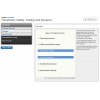
Transfusion Safety: Ordering and Administrating
Patient safety in ordering and administering of blood products. Topics...
$170.57 -
-
-